We have an application in an underground mine where location of equipment is important. So, we bought the MDEK1001 Development Kit.
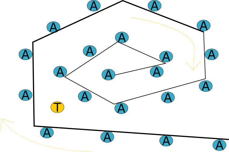
As shared in the following picture diagram, we will have more than 1Km of installed Anchors and the equipment will navigate with the Tags modules. The Anchors technically are installed in a line one following the other.
The application is that we have a raspberry like device on each equipment connect to a TAG (on each equipment) the equipment reads the distance to the closes anchors and sends this distance to a server. From the server we can see where all the equipment is based on the Anchor unique ID along the path.
I hope the application is well understood and my question are:
Anchors are all configured as initiator? Or just one Anchor or none. (All active).
What is the max distance between an Anchor and a TAG with line of sight.
Do Anchor’s need to hear each other in order for the application to work? I mean, Can I place the Anchors so far from each other that cannot see each other, I’m guessing more than the max between Anchor and TAG.
Anchors are all configured as initiator? Or just one Anchor or none. (All active).
From our experience from long corridors/ large installations it is still recommended to have only two initiators (one will act as backup one). These initiators should be within range with each other. If they are separated then it could take a long time to get stable network.
What is the max distance between an Anchor and a TAG with line of sight.
That is a complex question and it depends on may things. I would say 20-25m.
Do Anchor’s need to hear each other in order for the application to work? I mean, Can I place the Anchors so far from each other that cannot see each other, I’m guessing more than the max between Anchor and TAG.
Actually they must hear each other otherwise it would not work at all. Regarding the distance between anchors it is the same as between AN-TN. However there is a BUT - the TN need to hear at least three anchors to be able to calculate its position - you need to take care about this. In any place you want to track device the distance between tag and three anchors. It is recommended that TN should hear at least 4 anchors.
One more note: If you put the anchor into a square like shape with 20m separation then on the diagonal it is 28m - tag will be not able to hear all 4 anchors in corners!
Thanks for the quick response, I’ll consider your response into the design we will try in mine site.
I was wondering about just getting distance from TAG to Anchor? on our current deploy, we have used Bluetooth as Anchors to send a unique ID to the Equipment and this ID represents a “position” on the long corridor, so in terms of position is represented by equipment’s “hop” along the corridor.
We’re planning to use your solution to have more movement continuity by showing distance to each Anchor while moving from AN to AN.
So, is it possible to use distance only and not position (only to AN can see at the time not 3)?
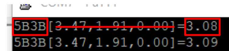
I’ve been experimenting with Anchors in a line and I saw on tag output the distance to each Anchor but I saw a problem that could come when deploying in mine site. the time sync number. One of our mine sites has more than 6km of length. so, I calculated with a 20m distance between AN-AN to get the max distance for the system to be capable of handling and is around 2.6Km when reaching the max time sync “127”.
Hi @jpernia
this might need a wider discussion. Could you contact us via our contact form https://www.leapslabs.com/about (scroll down to GET IN TOUCH form)? Just fill there your name, email and add a brief description of your needs or point to this discussion. My colleague will get touch with you and he will answer your questions.
As you’ve probably guessed from the answers I don’t think the standard PANS / MDEK positioning system is going to work too well for your situation.
A couple of questions on your application: How may pieces of equipment do you need to track? And the maximum number within say a 100m stretch? (If they are out of range then you don’t need to worry about them talking over each other). What update rate do you need? What accuracy do you need?
Most positioning systems can be re-designed to solve this sort of problem, we looked at it for our UWB system for a similar tunnel application. But I’ve never seen one that does this off the shelf, you’ll probably be looking at a custom solution of some sort.
To be honest for your application I’d be tempted to look at RFID. 900MHz class1 gen2 tags are cheap and have a range of ~20m. You put those say every 10m along the tunnel and a reader on the mobile equipment, scan to see which tags are in sight and you will be able to work out where you are to within ~5m. With the added advantage that the tags in the tunnel don’t need power, something that can be helpful in emergency situations. This approach will never give the accuracy of UWB so it does depend a lot on the requirements.
Basically, we just one distance for each Anchor the TAG finds on its way. The TAG will probably see two (2) Anchor at the time. In the Next Image there is a diagram of the expected application. we use the Raspberry to transfer the info throught a Wifi Network.
On mine site we have already a system base on RFID but we want to improve it by making it more fluid with info about distance between Anchors. Right now is a “Hop” system where the equipment “Hop” from anchor to anchor.